No edit summary Tag: Visual edit |
(→Continental layout: ref fixed) |
||
| (7 intermediate revisions by 3 users not shown) | |||
| Line 1: | Line 1: | ||
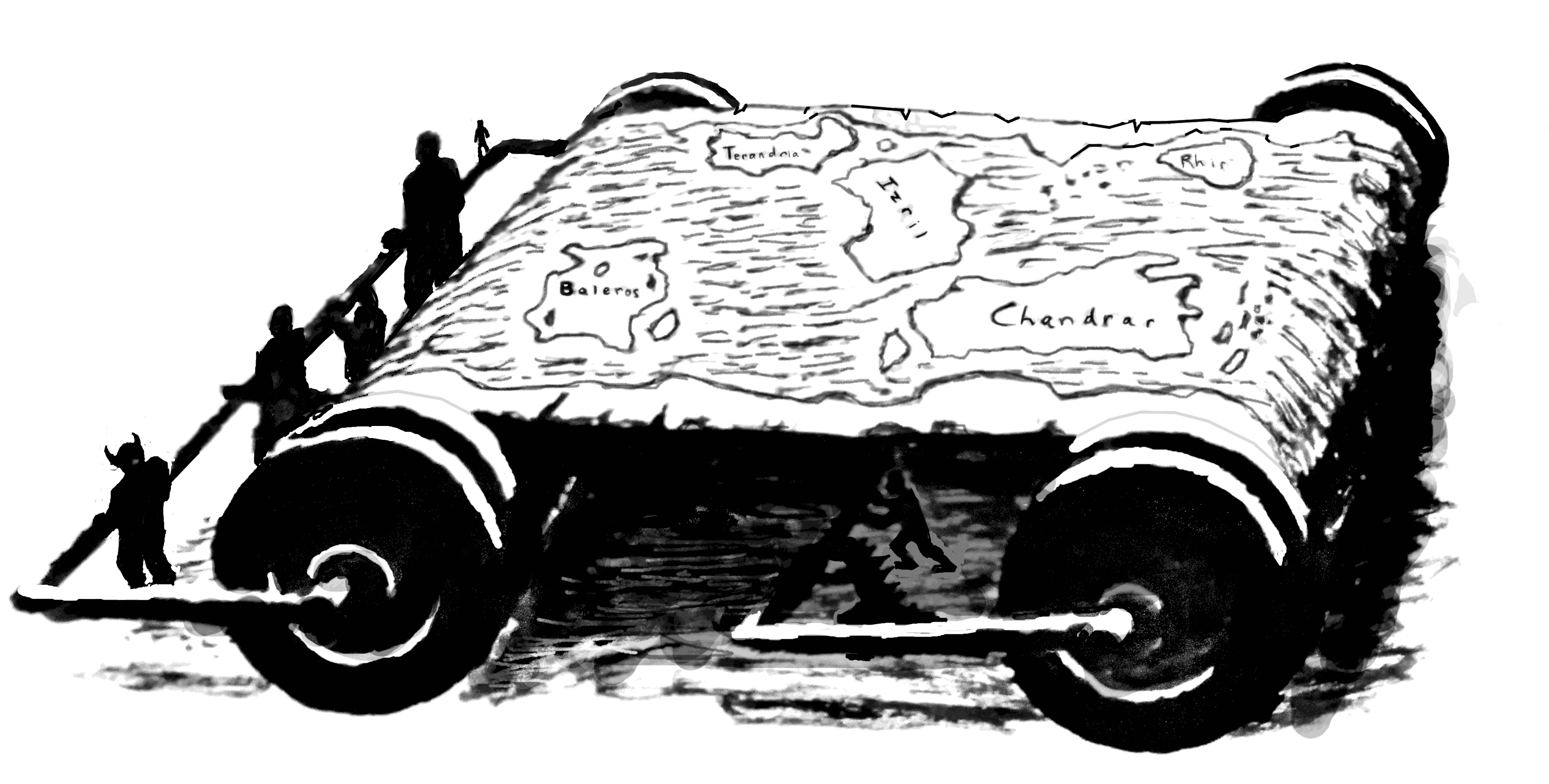
| + | [[File:Scrollmap by geoawk.png|thumb|right|400px|A map of Innworld as roughly outlined by Ryoka in Volume 2.<br/>Fanwork by geoawk.]] |
||
| − | (all locations of continents and Isles are being mentioned and the map is going to be included when it is available for non-patrons. For now it is just the '''general''' location) |
||
| + | Available maps are collected in the [[:Category:Maps|maps category]]. Note that they are mostly reader interpretations. |
||
| + | Short descriptions of the continents, as well as some fan-made maps, may be found in the article [[Innworld]]. |
||
| − | == Continents == |
||
| − | * [[Izril]] - Mid |
||
| − | * [[Terandria]] - North<ref name=":2.07">[https://wanderinginn.com/2-07/ Chapter 2.07]</ref> |
||
| − | * [[Baleros]] - South-West corner<ref name=":2.07" /> |
||
| − | * [[Chandrar]] - South-East corner<ref name=":2.07" /> |
||
| − | * [[Rhir]] - North-East corner<ref name=":2.07" /> |
||
| − | == |
+ | == Maps of Izril == |
| + | [[Selys Shivertail|Selys]] drew an impromptu map of [[Izril]] for [[Erin]] once, teaching her some basic geographical facts of Izril.<ref>[https://wanderinginn.com/2016/11/27/1-28/ Chapter 1.28]</ref> |
||
| − | <gallery widths="310" position="center" columns="2"> |
||
| − | Prototype map.jpg |
||
| + | === Magical Maps === |
||
| − | </gallery> |
||
| + | A 2000 years old map is inserted in the stone table of [[Manus]] where the leaders of that Walled City confer. Those magical maps can only be created with knowledge of the terrain, which is the reason why unexplored areas are blurred. Also, even magical maps don't update themselves.<ref>[https://wanderinginn.com/2019/07/23/6-33-e/ Chapter 6.33 E]</ref> Similar magical maps, that even allow zooming, are available in [[Salazsar]], in 'magical map rooms'.<ref>[https://wanderinginn.com/2018/06/12/4-45/ Chapter 4.45]</ref> |
||
| + | [[Niers Astoragon]] has a large map archive for his company, which probably contains maps for most locations. There is at least one magical map of Izril that allows a three-dimensional view.<ref>[https://wanderinginn.com/2019/02/19/5-61/ Chapter 5.61]</ref> |
||
| − | == Isles == |
||
| + | |||
| − | * Archipelago - East of Izril<ref>[https://wanderinginn.com/2016/11/06/1-03-r/ Chapter 1.03 R]</ref> |
||
| + | == Continental layout == |
||
| − | * [[Wistram]] - Southeast from Terandria |
||
| + | In Volume 2, [[Ryoka]] introduced the continents of the world to [[Erin]], by placing chess and kitchen pieces on a table of Erin's Inn. According to that scene, Issrysil ([[Izril]]) is the central continent (a pawn), surrounded by [[Terandria]] in the North (a saltshaker), the [[Baleros|humid jungle continent]] in the Southwest, the [[Rhir|blighted continent]] in the Northeastern corner and the [[Chandrar|desert continent]] in the Southeastern corner (probably the napkin).<ref name=":2.06">[https://wanderinginn.com/2-07/ Chapter 2.06]</ref> In the following chapter, the remaining continents were officially named.<ref>[https://wanderinginn.com/2017/04/04/2-08/ Chapter 2.07]</ref> |
||
| − | * [[Isles of Minos]] - East of Chandrar<ref>[https://wanderinginn.com/2016/10/26/interlude-king-edition/ Interlude – King Edition]</ref> |
||
| + | |||
| + | :''Note: Ryoka had done some reading at that point in the story, but her knowledge seems questionable. For example, she really wished to see [[Teriarch]]'s world map, indicating that she hadn't seen a proper one before, when she studied books during her injury downtime.<ref>[https://wanderinginn.com/2016/12/28/1-09-r/ Chapter 1.09 R]</ref>'' |
||
| + | |||
| + | In Volume 6, the [[United Nations|UN]] company acquired maps and confirmed several facts: Chandrar is the southernmost continent, while only Terandria and Baleros spread far enough to the north to have areas where it is cold and snowy all year round.<ref>[https://wanderinginn.com/2019/04/09/6-06-d/ Chapter 6.06 D]</ref> |
||
| + | |||
| + | Aside from the continents, there are also several important groups of islands. As far as we know, the [[Drath Archipelago]] is located east of Izril<ref>[https://wanderinginn.com/2016/11/06/1-03-r/ Chapter 1.03 R]</ref>, [[Wistram]] might be southeast from Terandria<!--according to a possibly outdated map for patreon readers--> and the [[Isles of Minos]] are east of Chandrar.<ref>[https://wanderinginn.com/2016/10/26/interlude-king-edition/ Interlude – King Edition]</ref> |
||
== References == |
== References == |
||
| Line 23: | Line 25: | ||
[[Category:Terminology]] |
[[Category:Terminology]] |
||
[[Category:Continents]] |
[[Category:Continents]] |
||
| + | [[Category:Maps]] |
||
| + | [[Category:Reference]] |
||
Revision as of 09:40, 20 December 2019
A map of Innworld as roughly outlined by Ryoka in Volume 2.
Fanwork by geoawk.
Available maps are collected in the maps category. Note that they are mostly reader interpretations.
Short descriptions of the continents, as well as some fan-made maps, may be found in the article Innworld.
Maps of Izril
Selys drew an impromptu map of Izril for Erin once, teaching her some basic geographical facts of Izril.[1]
Magical Maps
A 2000 years old map is inserted in the stone table of Manus where the leaders of that Walled City confer. Those magical maps can only be created with knowledge of the terrain, which is the reason why unexplored areas are blurred. Also, even magical maps don't update themselves.[2] Similar magical maps, that even allow zooming, are available in Salazsar, in 'magical map rooms'.[3]
Niers Astoragon has a large map archive for his company, which probably contains maps for most locations. There is at least one magical map of Izril that allows a three-dimensional view.[4]
Continental layout
In Volume 2, Ryoka introduced the continents of the world to Erin, by placing chess and kitchen pieces on a table of Erin's Inn. According to that scene, Issrysil (Izril) is the central continent (a pawn), surrounded by Terandria in the North (a saltshaker), the humid jungle continent in the Southwest, the blighted continent in the Northeastern corner and the desert continent in the Southeastern corner (probably the napkin).[5] In the following chapter, the remaining continents were officially named.[6]
- Note: Ryoka had done some reading at that point in the story, but her knowledge seems questionable. For example, she really wished to see Teriarch's world map, indicating that she hadn't seen a proper one before, when she studied books during her injury downtime.[7]
In Volume 6, the UN company acquired maps and confirmed several facts: Chandrar is the southernmost continent, while only Terandria and Baleros spread far enough to the north to have areas where it is cold and snowy all year round.[8]
Aside from the continents, there are also several important groups of islands. As far as we know, the Drath Archipelago is located east of Izril[9], Wistram might be southeast from Terandria and the Isles of Minos are east of Chandrar.[10]